Thursday, 11 April 2024
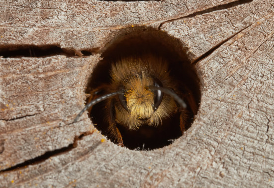
Around 270 species of bees are found in the UK, with nearly 90% solitary species. Some that can be seen in Scotland include the red mason bee, common carder bee and the chocolate mining bee that...
Wheeled transport - such as pushchairs, wheelchairs, motorised scooters - may have difficulty on a small section of the path on the way to the pond and hill.
This section was washed out by heavy rain and we are still awaiting repairs. Please take care while using the track until repairs can be carried out.
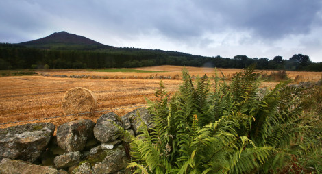
The curving graceful ridge of Bennachie stands proud in the landscape and stirs the hearts of everyone who comes here. It’s Aberdeenshire’s best-loved forest, an ancient place with colourful stories, wide-ranging wildlife, amazing archaeology and panoramic views from its distinctive tops.
There are four different ways into the hill, each with a picnic area and forest trails. But if you’ve never been to Bennachie before, the best place to head for is the Bennachie Visitor Centre.
Bennachie Visitor Centre route card (PDF)
A gentle wander through the forest. Wildlife rubbing posts are dotted along the trail; collect paper and crayons from the visitor centre.
A smooth firm trail, with short gentle slopes and no obstacles.
½ hours
Check the Bennachie Discovery Trail Phototrail for full details about access along the route.
An easy-going trail winding through attractive open woodland and the ruined houses and fields of the Bennachie colonists.
Firm and generally smooth, with some uneven areas. Generally moderate slopes, with some short fairly steep parts. Includes steps, roots and rocky areas.
1¼ hours
Find out more about the colonists who lived and worked on Bennachie in the 1800s along this route.
Climb to the rocky granite top of the Mither Tap, with its superb views and impressive Pictish fort.
A very steep, rough trail with roots, rough rock steps and drains. Narrow in places. The summit is slab rock and can be slippery when wet.
2¾ hours
The trail will take you back in time, through forest planted in the 1950s and into a landscape formed over 10,000 years since the last Ice Age.
Many visitors want to climb the Mither Tap, the most distinctive of Bennachie’s nine summits. The shortest route is the steep Timeline Trail from Bennachie Visitor Centre, but there are plenty of other ways to the top. From Rowantree car park a popular route follows an ancient trackway, and from Back O’Bennachie there’s a longer trail that’ll take you through an old quarry. From Donview you can climb Millstone Hill, a remote, less well-known summit, and continue to the Mither Tap for a really big day out.
For more adventure, try the Gordon Way, an 11 ½ mile (18.5 km) route through forests, farmland and moorland that starts (or ends) at Bennachie Visitor Centre. All of these trails cross open country and hill ground, where the weather can change quickly. Check our advice on hillwalking before you set off.
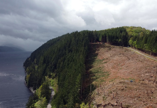
Bennachie is home to a great diversity of wildlife, including the charismatic red squirrel, and many different species of birds.
Come and watch these fascinating forest animals from our new wildlife viewing area near the Bennachie Visitor Centre. We’re planting wildlife-friendly trees here and putting up information panels to help you identify the birds and animals you spot.
The visitor centre is open until the end of October.
It's run by the Bennachie Centre Trust. For more details, contact them on 01467 681470 or email bennachie.warden@aberdeenshire.gov.uk.
The car park is open at any time, all through the year. Secure bike parking is available.
The charges to park at Bennachie Visitor Centre are:
We recommend you bring both coins and card with you, just in case. Please park with care and consideration. In particular please park in designated parking areas only and do not block entrances or gates. Nearby car parks with free parking can be found in our local forest list without the £ symbol.
Available in advance by downloading the relevant application form and emailing to the Regional Office. Please read our Annual Pass terms and conditions before applying.
Valid at Roseisle, Culbin, Winding Walks, Back o'Bennachie, Bennachie Centre, Countesswells, Foggieton, Scolty, Cambus o’ May, Torrieston, Dunnottar Woods, Quarry Wood (Leggat)
Valid at all Forestry and Land Scotland car parks except Tentsmuir.
Blue badge holders park free. Please display your Blue Badge clearly.
![]()
From the first roundabout on the A96 at Inverurie, continue north towards Huntly. After about 3.5 miles (5.5 km) on the A96, take a road on the left signposted to Chapel of Garioch. Take the first left in Chapel of Garioch signposted to the Bennachie Centre. Follow this road for about 2 miles (3.2 km) continuing until the next brown Bennachie Centre sign where you will reach the car park at grid reference NJ 698 216.
The nearest point for public transport is the village of Pitcaple, about 3 miles (4.8 km) away on the A96. It is served by buses between Huntly and Aberdeen. Alternatively, you could take a taxi from Inverurie, about 6.5 miles (10km) away, which is served by buses and trains. Check Traveline Scotland for details.
Have a question or suggestion for improvement?
The best views of Bennachie on a quieter walk to the summit
A favourite start point for those climbing Oxen Craig
Thursday, 11 April 2024
Around 270 species of bees are found in the UK, with nearly 90% solitary species. Some that can be seen in Scotland include the red mason bee, common carder bee and the chocolate mining bee that...
Thursday, 04 April 2024
Thursday, 21 March 2024
Wednesday, 13 March 2024
We recently p...