Wednesday, 21 Jan 2026
Red Squirrel Appreciation Day falls on the 21 January this year and we're sharing some of our favour…
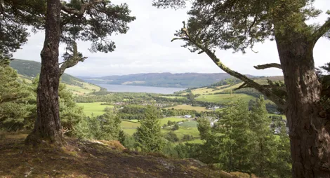
Pause to soak up the panorama of Loch Ness and the Great Glen on the quiet south side of the loch. This is a great spot for a picnic and is one of the best places to enjoy a stroll on the stony shore of Loch Ness.
You can feel the sweep of history as you take in the magnificent scenery. Across the loch stands the dramatic remains of a 500-year-old royal castle. You’ll also find a short trail along the shore takes you to the ruins of the Change House. This is where travellers, including the 18th century writer Dr Samuel Johnson, rested and changed horses on long journeys.
Wander through hazel woods along the shore of Loch Ness to the ruins of the Change House.
Mostly firm but sometimes uneven gravel path with a short steep slope.

Allow ½ hours
On the trail you pass the atmospheric ruins of Change House, a staging post where travellers could rest and change horses. Celebrated writers Dr Samuel Johnson and James Boswell stopped here during their ‘Highland Jaunt’ in 1773. Recording that it was a simple place, its dark smoky interior heated with a peat fire. The owner, they wrote, was ‘an old woman, boiling goat’s flesh in a kettle’.
The South Loch Ness Trail passes close to Change House. This 28 mile (45km) route links Loch Tarff near Fort Augustus with Torbreck on the edge of Inverness. Most of the trail is easily accessible, cycling and horse-riding. It roughly follows the line of the historic General Wade’s Military Road along the loch shore.
There are public toilets, parking and places to eat and drink in the nearby villages of Dores (5 miles) and Foyers (6 miles).
There is no charge to park in this car park.
Change House is on the south side of Loch Ness beside the B852.
From Inverness, take the B862 to Dores and then the B852 towards Inverfarigaig. The parking area is beside the road on your right after about 5 miles (8km).
From Fort Augustus, take the B862 to Whitebridge and then the B852 via Foyers to Inverfarigaig. The parking area is beside the road on your left after about 3 miles (5km).
IV2 6TX is the nearest postcode, but it’s about 3 miles (5km) north of the car park on the B852.
There is an infrequent bus service between Inverness and Fort Augustus that travels along the south shore of Loch Ness. You’ll find details at Traveline Scotland.
Have a question or suggestion for improvement?

Spectacular views over Urquhart Bay from the crag named after a Viking Prince

Towering trees, wonderful wildlife and spectacular views of Loch Ness’ south shore

A gentle, atmospheric stroll through oakwoods to a magnificent waterfall