Wednesday, 21 Jan 2026
Red Squirrel Appreciation Day falls on the 21 January this year and we're sharing some of our favour…
This attractive, circular riverside walk is topped and tailed by two historic bridges. As you stroll by the Blackwater river, you’re walking in the footsteps of soldiers – and cows! Silverbridge is part of an ancient route used by drovers (cattle herders) on their way to the markets in the south.
The high-arched bridge at Little Garve was part of a military road which was built between Contin and the west coast at Poolewe around 250 years ago. It’s known as Wade’s Bridge, but it was actually built by Wade’s successor, Major William Caulfeild. Look out for brown trout in the pools below the bridge.
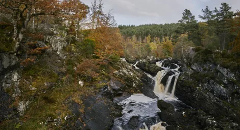
Wander beside a series of peaty pools and gushing rapids along the Black Water River between the historic Wade’s Bridge and Silverbridge.
Moderate and steep slopes and several flights of uneven steps. Includes sections of rough and uneven earthy and rocky path. Some narrow sections.

Allow 1 ½ hours
This is a gorgeous trail any time of year, but in autumn the native trees are particularly colourful and high water levels make the river roar. You can start and finish this trail from either end.
You can park and picnic at both ends of this circular trail, in Little Garve and in Silverbridge. There are public toilets at Silverbridge and Rogie Falls, both run by the Highland Council, which are usually open all year round.
You'll find other toilets, shops and places to eat in Strathpeffer and Dingwall.
There is no charge to park in this car park.
From Inverness, follow the A9 north to the Tore roundabout. Take the second exit onto the A835 (for Ullapool) and stay on this road for about 18 miles (28.8 km). About 2 miles (3.2 km) after Garve you'll see forest signs to Little Garve on your right. Turn here and follow the minor road to the car park at grid reference NH 395 629.
To start from Silverbridge, continue on the A835 for another mile. The car park is on your left at grid reference NH 404 640.
Nearest postcode: IV23 2PU
There are train and bus services from Inverness to Garve, just under 2 miles (3.2 km) from the car park. See Traveline Scotland for details.
Have a question or suggestion for improvement?

Climb this isolated Munro or enjoy the native woodland on its lower slopes

Short walks rewarded with spectacular waterfall views

Small picturesque loch set within sloping birch and oakwoods