
Thursday, 05 Mar 2026
It’s Scottish Apprenticeship Week! Apprentices are an important part of our workforce - helping us …
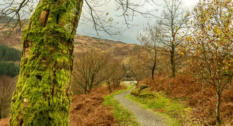
A tranquil spot at the heart of Galloway Forest Park. Take the scenic trail beneath the Merrick to discover the lively waters that meet at Loch Trool. This area's history is also written into the landscape. Look out for Bruce's Stone, overlooking the site of the Battle of Glen Trool. There is also a monument to 17th century Covenanters who were slain for their religious beliefs.
For those seeking a few more thrills, Glentrool is one of the 7stanes mountain bike centres. You’ll find a mix of trails for novice and experienced riders.
And once you've completed your outdoor adventures, unwind in the café and watch woodland birds busy on the feeders.


Can you spot tiny goldcrests on this circular trail through tranquil conifer woodland?
A smooth gravel path with moderate gradients, with some short fairly steep ramps.

Allow ¾ hour
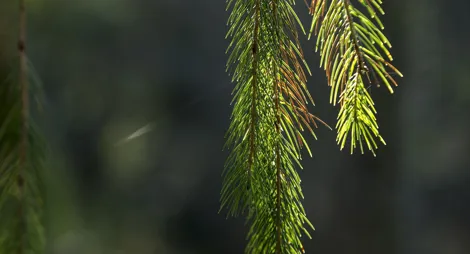
As you go, listen out for the high, piping call of tiny goldcrests as they flit through the conifer canopy. These busy insect-eaters are the smallest birds in the UK.
Wind through the birch woods along the rushing Waters of Minnoch and Trool and look up to the high Galloway Hills.
Mostly loose gravel surface, with short uneven section. Includes one steep slope. Look out for vehicles along the short road section.

Allow 1 ½ hours
A scenic trail through the oakwoods alongside the Water of Trool. Discover the tragic Martyr’s Tomb and a magnificent viewpoint by Spout Head Waterfall.
Loose gravel surface throughout, with occasional uneven sections. Long slopes with several short steep sections. Includes two road crossings and a pair of bridges (one 0.9m wide).
Allow 2 ½ hours
Winding through the woods you'll see the poignant Martyrs' Stone. This is where six Covenanters were killed in 1665 because of their convictions to obey God rather than the King. Enjoy spectacular views down Loch Trool as you return through the forest. Keep and eye out as you’ll be passing the pretty Spout Head Waterfall.
You can extend this trail to make a full day out by joining the Loch Trool Loop. This has green waymarkers starting at the bridge over the Water of Trool. The path will take you right round Loch Trool and past the historic Bruce's Stone.
A circuit of stunning Loch Trool and its untouched native oak woodlands. Great views throughout over the loch to the foothills of Merrick.
Loose and occasionally uneven gravel surface. Steeply rolling terrain with some long fairly steep slopes. Includes a bridge 0.9m wide, some steps and a section along the road.

Allow 4 hours
Listen hard and perhaps, above the gentle lapping of the loch, you might also hear the ancient roar of combat. Here on the Steps of Trool, a bitter battle was fought between the English and the Scots during the Wars of Scottish Independence 700 years ago.
This trail starts at Caldons car park, at the western end of Loch Trool. From Glentrool Café, follow signs to Loch Trool and Bruce’s Stone. After about 1½ miles (2.5 km), turn right into the car park. You can extend this trail to make a full day out by joining it with the Water of Trool Trail (yellow waymarkers) at Caldons car park. This takes you through the forest to Glentrool Visitor Centre then back through the glen along the lovely Water of Trool.

Glentrool is one of the world class 7stanes mountain bike venues. It features green and blue graded trails and is the starting point for an epic 36 mile offroad journey into the heart of Galloway Forest Park.
Glentrool 7stanes route card (PDF)
Grade - Green: Easy ![]()
Expect relatively flat, wide, and smooth trails. Gentle climbs, descents, rollers and berms, with easy to avoid features such as rocks and potholes. Surface might be loose, uneven or muddy at times.
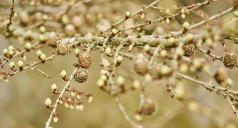
The Glen is a short leisurely trail around the picturesque Palnagashel Glen. Suitable for families looking for an unhurried pace. Enjoy picturesque views of Palnagashel Glen, on this short but sweet route that meanders along the banks of Black Linn and through tall larch trees. There’s forest track and a section of gentle singletrack.
Grade – Blue: Moderate ![]()
Expect a mixture of climbs and descents with moderate gradients, technical features like tree roots and rock steps; jumps and berms. Rollable features at controlled speed. Variable surfaces.
The Green Torr climbs gradually up through the forest to stunning views over Loch Trool. This ride mainly features purpose built singletrack, and the lack of large rocks and tree roots make it welcoming to less experienced mountain bikers. The most challenging section is the steady 218 metre climb through forest to the Green Torr, after which you can enjoy the long final descent back down to the Glentrool Visitor hub.
Take a day long ride into the wild heart of Galloway Forest Park with magnificent views of the nearby lochs and hills. Embark on an epic journey that encompasses staggering views of Galloway’s lochs and hills. This route takes you along minor public and forest roads, and while there’s no technical singletrack, the Big Country route still offers a challenging ride with long climbs and sharp descents.
Glentrool is a great place to watch wildlife. There is a variety of woodland birds that visit the feeders or flutter in the canopy overhead. Look out forgreat tits, goldcrests and crossbills. Red squirrels and roe deer are also regular visitors to the woods around the centre, especially early in the morning and at twilight.
We’ve established a mountain garden at Glentrool to protect and breed special wee trees. These trees grow high on the hills at the very edges of the woods. These small, stunted trees look quite unremarkable but are an important remnant of rare mountain woodland. Look out for tiny junipers and a variety of minute mountain willows. Willows love wet places – their Latin name Salix comes from the Celtic sal (near) and lis (water).
Scotland has some of the darkest skies in Europe, and Galloway Forest Park is one of the darkest places in the country – which is why it’s the UK’s first Dark Sky Park.
National Cycle Route 7 winds through Galloway Forest Park. It links Glentrool with the two other visitor centres here. You might not want to tackle the whole 200 miles but you can still get a taste of the experience on shorter, scenic stretches of the route.
Learn more about the cycle route
The Southern Upland Way runs along the Water of Trool just below Glentrool Café. This is Britain's first official coast to coast long distance footpath.It’s 212 miles (340 km) and goes from Portpatrick on the west coast to Cockburnspath on the east coast. It’s a dramatic and challenging route through the rolling hills of the Southern Uplands. Sample a scenic stretch from Glentrool to Loch Trool and see if you’re inspired to walk the rest.


The café has toilets (with fully accessible facilities) and a warm welcome. Toilet facilities are only open during normal café opening times.
The café is open from 10.30am to 4.30pm.
The charges to park at Glentrool are:
Blue Badge holders park free. Please display your Blue Badge clearly.
Payment can be made using coins, card or RingGo.
Annual parking passes are available for this site, visit our parking page for more information.
Whilst overnight parking is not permitted in most FLS car parks, overnight parking is permitted at this car park for mountain access. Remember, no camping or sleeping in vehicles at the car park. Please pay for each day. You can pay up to 72 hours later, when you pay by RingGo.
Please park with care and consideration. In particular please park in designated parking areas only and do not block entrances or gates. Nearby car parks with free parking can be found in our Forest Search.
Our Stay the Night scheme now runs right through the year. This means self-contained motorhomes and campervans will be able to park overnight for one night in some of our car parks.
There is a £10 charge to Stay the Night at this car park. Payment can be made through RingGo with details of how to do this at each car park.
To help plan your stay, please see the details below:
Please visit our Stay the Night page for full details, participating locations, best practice, and terms and conditions of use.
Dogs are welcome in the café.

The turn in for Glentrool is signposted from the unclassified road that passes north from Glentrool village.
DG8 6SZ is the nearest postcode.
Have a question or suggestion for improvement?
Short walk to one of Scotland's most beautiful views
An old oak woodland that's a haven for wildlife
Historic viewpoint at the head of a long tree-clad gully
Thursday, 05 Mar 2026
It’s Scottish Apprenticeship Week! Apprentices are an important part of our workforce - helping us …

Wednesday, 25 Feb 2026
Guest blog by Beat Forester Sam Brown. There has been a lot going on in the glen over the past two y…

Wednesday, 21 Jan 2026
Red Squirrel Appreciation Day falls on the 21 January this year and we're sharing some of our favour…