Wednesday, 21 Jan 2026
Red Squirrel Appreciation Day falls on the 21 January this year and we're sharing some of our favour…
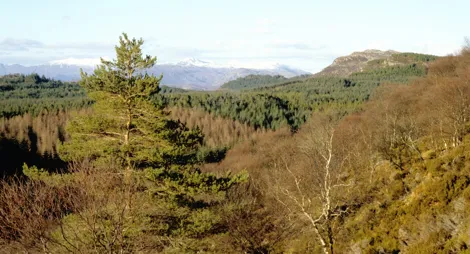
Two trails lead to the summit of Cnoc a' Mhadaidh-ruaidh (the hill of the fox), where there are superb open views over the island and Raasay all the way to the Cuillin mountains.
It's an easy walk here from Kyleakin village or across the Skye Bridge from Kyle of Lochalsh. If you want to get close to nature and see Skye, this is a great place to start!
From Cnoc a' Mhadaidh-ruaidh you have excellent views of Eilean Bàn – the tiny island where writer and naturalist Gavin Maxwell once lived. The island is managed by the Eilean Bàn Trust.
A satisfying woodland climb to the top of Cnoc a' Mhadaidh-ruaidh with fantastic views over Eilean Bàn .
A short but undulating path with short steep sections. Smooth gravel surface, narrow, rocky and uneven in places.

Allow 1 hour
The most direct route to the summit takes you through pleasant mixed woodland and conifers. As you climb there are views over Stevenson's lighthouse and the Skye Bridge, and from the summit viewpoints you can also see Raasay, the Red and Black Cuillins and the mountains of the mainland.
This trail winds round the hill over heather covered hills, giving great views out over the sea towards Raasay, Applecross and the Inner Sound.
An undulating and winding trail, with some steep long sections. Can be narrow, rough and rocky in places. Includes uneven wooden steps and slab rock sections.

Allow 1 ½ hours
The nearest public toilets and eating places are in Kyleakin (less than a mile / 1.6 km) away or over the Skye Bridge in Kyle of Lochalsh (1½ miles / 2.4 km) away.
There is no charge to park in this car park.
There's limited layby parking at the start of the trails, but plenty in Kyleakin village less than a mile (1.6 km) away. From the Skye Bridge go straight over the first roundabout and continue uphill. Almost immediately on your right you'll see parking for two or three cars and the start of the trails.
Please park with consideration and do not block pedestrian and vehicle access points. Do consider public and active transport if available and possible.
IV41 8PH is the nearest postcode.
Buses stop in Kyleakin and connect with Fort William and Inverness. You can also take a train to Kyle of Lochalsh from Inverness. Regular buses run from Kyle of Lochalsh to Kyleakin, or you can walk the 1½ miles (2.4 km) from the railway station to the trails. You'll find timetable details at Traveline Scotland.
Have a question or suggestion for improvement?

Walk beneath the trees beside Loch Alsh

The perfect place for a bit of otter-spotting

Panoramic views over picturesque Loch Alsh