
Thursday, 05 Mar 2026
It’s Scottish Apprenticeship Week! Apprentices are an important part of our workforce - helping us …
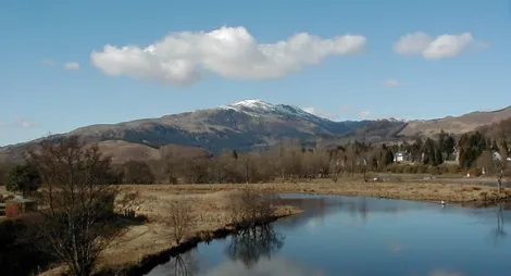
Steeped in geological and human history, Bochastle sits just outside Callander where the Garbh Uisge and Eas Gobhain converge to form the River Teith. Can you find Samson’s Putting Stone? This massive rock is perched on the hillside. The site is also home to a roman fort dating back to 1 AD.
Bochastle is ideally placed to link up with other national long-distance routes.
From Bochastle you can join the NCN 7 cycle route, Rob Roy Way, and The Great Trossachs Forest Path. The riverside path to the Falls of Leny and an alternate start to the hill path for Ben Ledi can also be found here.

Parking is free in this car park during the day.
Please note, overnight parking is not permitted unless part of our Stay the Night scheme – see below.
Our Stay the Night scheme now runs right through the year. This means self-contained motorhomes and campervans will be able to park overnight for one night at the Bochcastle car park.
There is a £10 charge to Stay the Night at this car park. Payment can be made through RingGo with details of how to do this at each car park.
To help plan your stay, please see the details below:
Please visit our Stay the Night page for full details, participating locations, best practice, and terms and conditions of use.
Bochastle lies just outside Callander on the A821 near it’s junction with the A84. The car park is clearly signed and is on the right-hand side of the A821 from Kilmahog to Aberfoyle just after the Lade Inn.
Closest postcode is FK17 8HD
Have a question or suggestion for improvement?
Climb the Trossachs' highest summit

Panoramic views of both the Highlands and the Lowlands
Lochside cabins beneath the peaks of Ben Ledi
Thursday, 05 Mar 2026
It’s Scottish Apprenticeship Week! Apprentices are an important part of our workforce - helping us …

Wednesday, 25 Feb 2026
Guest blog by Beat Forester Sam Brown. There has been a lot going on in the glen over the past two y…

Wednesday, 21 Jan 2026
Red Squirrel Appreciation Day falls on the 21 January this year and we're sharing some of our favour…