Wednesday, 21 Jan 2026
Red Squirrel Appreciation Day falls on the 21 January this year and we're sharing some of our favour…
The Southern section of the trail is closed due to forestry operations. The Northern section remains open.
Despite the legends, it’s unlikely that Robert the Bruce sheltered in the King’s Cave before the Battle of Bannockburn – or saw the famous spider. But the cave is still worth a visit. It’s set in sandstone cliffs along a raised shingle beach with amazing inscriptions. Bring a torch to help you explore.
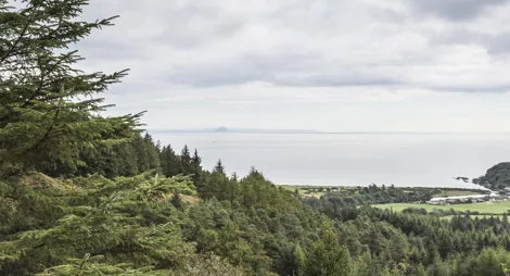
The circular trail begins and ends in pleasant mixed forest with scenic views of Machrie Moor and Drumadoon Cliffs.
A beautiful circuit of forest and shoreline with wonderful views inland and across Kilbrannan Sound. Discover legendary King’s Cave where Robert the Bruce is said to have sheltered.
Generally firm but uneven gravel and earth surface. Rough rocky section along the shore and some narrow stretches. Several long steep slopes and two gates.

Allow 2 hours
The sea level around Arran was once over 30 feet (10 metres) higher than it is now, so there is a steep descent to get down onto the beach. You'll see the King's Cave in soft sandstone cliffs above the beach, towards the end of the coastal section.
Blackwaterfoot has the nearest public toilets and eating places.
There is no charge to park in this car park.
Travel by ferry from Ardrossan in North Ayrshire to Brodick.
From Brodick take the B880 (The String) west across the island to Blackwaterfoot. Turn right onto the A841 and travel through Blackwaterfoot towards the north for just under 3 miles (4.8 km) until you see the car park on your left, at grid reference NR 898 315.
Nearest postcode: KA27 8DX
The nearest bus stops are at Machrie, Blackwaterfoot and Shiskine. You'll find details at Traveline Scotland.
Have a question or suggestion for improvement?

A steep climb to sweeping mountain and island views

Burnside trails, gentle waterfalls, and a climb to lonely Urie Loch

Start exploring Arran, with cairns, standing stones and lots of red squirrels